
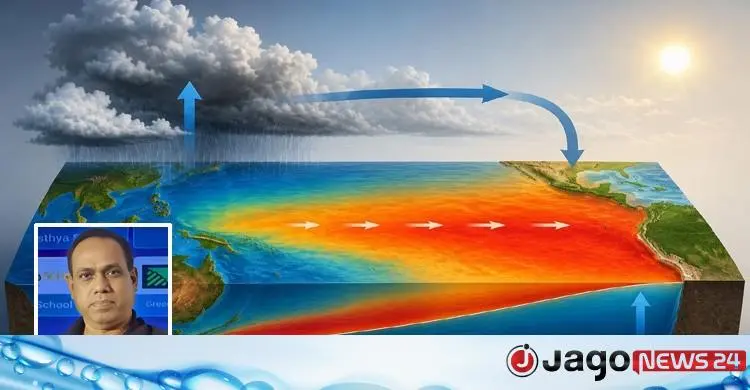
Nature is never still. The earth's climate is an ongoing, complex process in which the ocean, atmosphere, sun, clouds, wind and the earth's rotation constantly interact. One of the most important natural events in this vast system is El Nino. It arises in the Pacific Ocean, but its effects are felt on almost every continent, and Bangladesh is no exception. International weather and climate research agencies have recently warned that El Nino may strengthen quickly between July and September. That raises questions: what is El Nino, why does it happen, where does it start, how far do its effects reach, what risks does it pose for Bangladesh and the world, and, most important, what should we do?
What El Nino is
In Spanish, El Nino means "the little boy" or "the Christ child". Fishermen in Peru named it after noticing an unusually warm flow of Pacific water around Christmas. Scientifically, El Nino is a marked rise in sea surface temperature above normal in the central and eastern equatorial Pacific. It is the warm phase of a large climate cycle called the El Nino-Southern Oscillation. It usually occurs every two to seven years and can last nine to 12 months, sometimes longer.
Normally, trade winds blowing from east to west push the Pacific's warm water towards Indonesia and Australia. Cold, nutrient-rich deep water then rises along the South American coast, a process called upwelling. When the trade winds weaken or reverse, the warm water flows back east and gathers in the central and eastern Pacific, and sea surface temperatures rise quickly. The warmer ocean changes air pressure, cloud formation, rainfall and wind patterns, and so El Nino is born. It is not simply a warming of the sea but a complex joint change in ocean and atmosphere.
El Nino originates in the central and eastern equatorial Pacific, but its effects are not confined there. They are seen in South Asia, South-East Asia, Australia, Africa, North and South America and parts of Europe. El Nino does not form over Bangladesh, but it can weaken the monsoon, change rainfall patterns and intensify heatwaves here.
Why July to September matters
July to September is the most important part of the South Asian monsoon, and a large share of Bangladesh's annual rainfall falls then. If El Nino strengthens in this period, the monsoon may weaken, rainfall may be below normal, long heatwaves and drought may occur, and farm output may suffer. But El Nino does not mean every area will get the same weather: local conditions, Bay of Bengal temperatures, the state of the Indian Ocean and other climate factors also play an important part.
Likely effects
- Temperature: El Nino usually raises the global average temperature, and combined with global warming in recent years it can bring record heat.
- Rainfall: many areas of Bangladesh, India, Thailand, Indonesia and Australia may get less rain than normal, putting pressure on farming, drinking water and irrigation.
- Crops: output of rice, maize, wheat, pulses and vegetables may fall, and irrigation costs will rise without enough rain.
- Wildfires: dry weather may increase the risk of wildfires in parts of Indonesia, Australia and South America.
- Fisheries and coral: warm water shifts fish habitats; fish catches off Peru and Ecuador may fall, and coral reefs may be badly damaged.
- Food prices: lower farm output may push up world food prices, with instability especially in rice, wheat, maize, edible oil and animal feed markets.
- Health: extreme heat raises the risk of heatstroke, dehydration and heart complications, especially for children and the elderly, while heavy rain elsewhere can increase diarrhoea, dengue and other mosquito-borne diseases.
For Bangladesh the impact of El Nino is indirect rather than direct, but it is still very significant.
Is climate change to blame?
The answer is somewhat complex. El Nino is a natural climate cycle that has occurred for many thousands of years. But because human-made climate change has raised the earth's average temperature, El Nino's effects can in many cases be more severe. Climate change does not cause El Nino, but it can amplify its harmful effects.
El Nino is now tracked with satellites, floating buoys at sea, ships, weather stations and supercomputer climate models. By analysing sea surface temperature, air pressure, wind speed and ocean currents, scientists try to forecast conditions several months ahead, although nature's complexity means a perfectly accurate forecast is not always possible.
What should be done
A natural event like El Nino cannot be prevented, but much of the damage can be reduced. At government level, weather forecasts and early warnings should be strengthened, water conservation and irrigation efficiency improved, drought-tolerant crop varieties expanded, back-up plans made for power and energy, and the health sector's preparations for heatwaves stepped up.
Farmers should time their planting by the weather forecast, use water-saving irrigation, choose drought-tolerant varieties and set up rainwater harvesting. The public should drink enough water in extreme heat, avoid going out needlessly in the midday sun, cut waste of electricity and water, plant trees and help protect the environment, and follow warnings from the Meteorological Department.
El Nino is a natural but very powerful part of the earth's climate system. It begins in the Pacific thousands of kilometres away, but its effects can reach Bangladesh's farming, economy, health, energy and food security. July to September matters especially because it is the core of the monsoon and the farming season.
There is no reason to panic, however. With science-based forecasts, effective planning, skilful water and farm management and public awareness, the possible damage from El Nino can be greatly reduced. In a world facing climate change, our greatest strengths are scientific information, timely preparation and coordinated effort. Nature cannot be stopped, but its challenges can certainly be met with knowledge, planning and foresight.
Source: Jagonews24. First published in Bengali on The Agro News.

Comments
(0)