
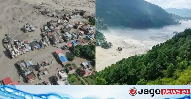
On 26 August a terrifying mass of Himalayan ice, rock and sediment came down in Nepal's Rasuwa district, setting off a flash flood whose impact spread across the mountains as far as Tibet. Within minutes rivers turned into torrents of destruction, sweeping away bridges, roads, settlements and hydropower infrastructure. The water, silt and huge boulders that poured into the Bhote Koshi and Trishuli river systems have created fresh risks in the area.
At first the event was thought to be an earthquake-triggered disaster, but later scientific analysis changed the picture. According to Reuters, a large collapse of ice and rock in the high Himalaya pushed a vast amount of material into the river system and produced a sudden surge of water; this has emerged as the main explanation, although scientific investigation of every stage of the event is still under way.
The disaster is not only a humanitarian tragedy for Nepal; it is an important warning for the Hindu Kush-Himalaya region. A compound or cascading disaster that starts in the mountains can create risks for communities far down a river. For a downstream country like Bangladesh, the event in Nepal is therefore not a distant disaster but a reason to rethink rivers, climate, mountains and regional disaster management.
Bangladesh offers help
Bangladesh has formally expressed deep sorrow and solidarity over the floods and landslides in Nepal. On 27 August Foreign Minister Dr Khalilur Rahman spoke by telephone with Nepal's Foreign Minister Shishir Khanal. Bangladesh said Dhaka was ready to help Nepal if needed and asked whether any Bangladeshi citizens had been killed or injured.
International assistance was also quickly mobilised. India, the United Nations and various other countries and organisations prepared rescue and humanitarian aid, and the disaster has already become a regional humanitarian crisis. The lesson is that when a disaster does not respect borders, rescue, information and warnings cannot stop at borders either.
What happened in Rasuwa
On the morning of 26 August a huge amount of ice, rock and debris crashed from the high ground of Rasuwa district into the river system below. Preliminary observations indicate that the ice-rock collapse took place in the area of a tributary of the Lhende Khola. The debris entered the river, created a sudden surge and then rushed downstream along the Bhote Koshi and Trishuli rivers.
The impact reached the Gyirong area of Tibet, where roads, power infrastructure and other structures were damaged. Chinese authorities are also monitoring a dammed lake, a naturally blocked body of water, for the risk of a second surge. So this was not simply a flood: it was a terrible example of an ice-rock avalanche, massive debris in a river, a sudden surge and cascading hazards in a river basin.
Casualty figures still unsettled
The casualty figures are not yet settled, and official and international counts at different times on 27 August differ. Nepal's Kathmandu Post, citing an official midday count, reported that the death toll had reached 270 and that 826 people could not be contacted, of whom 644 were tourists: 517 foreigners and 127 Nepalis.
On the same day, reports by international organisations put the number of dead and missing in Nepal and Tibet combined even higher. Reuters said the figures differ because rescue operations are continuing and communications have been damaged. It is therefore risky to define the scale of the disaster by any single final number. It can be said that hundreds of people have died and more than a thousand are missing or out of contact in Nepal and Tibet together, and the final count may change until rescue and identification are complete. According to Reuters, the missing in Nepal include foreign tourists and pilgrims, with Indian, American, Ukrainian, Australian, British, Malaysian and Canadian nationals reported missing.
Earthquake or avalanche?
This question lies at the heart of the disaster's scientific puzzle. Early on, reports of an earthquake in Nepal emerged, and the United States Geological Survey's earthquake catalogue recorded a magnitude 5.2 quake north-west of the Kodari area on 26 August. But it is no longer safe to treat that earthquake as the direct cause of the flood.
Preliminary analysis by the United States Geological Survey and the International Centre for Integrated Mountain Development (ICIMOD) said an ice and rock avalanche was likely at the site and that unusual signals had been picked up by seismic instruments, though a direct causal link between those signals and the flood had not then been established. Later international scientific analysis sees the ice-rock avalanche as the main explanation. So although an earthquake was present, it would be wrong to jump to the simple conclusion that the earthquake caused the flood. This is where the disaster's scientific importance lies: a collapse in the mountains can itself release so much energy that it registers as a seismic signal like an earthquake.
Thirty feet in thirty minutes
The most frightening feature of the disaster was its speed. According to ICIMOD, the water level on the Trishuli river at Galchi rose by about 9 metres, nearly 30 feet, in just 30 minutes. At Malekhu the level rose by about 7 metres over roughly the same period.
In flash floods of this kind there is very little time to warn people. Forecasts given hours or days ahead, as for ordinary floods, may not be enough. A collapse high in the mountains can turn a river within minutes into a flow faster than people's usual preparations can handle. That is why rain forecasts alone are not enough for disaster management in the Himalaya: ice, rock, rivers, landslides, seismic signals and sudden changes in river water all need to be watched together.
What it means for Bangladesh
There is no scientific basis for claiming that the event in Nepal will directly cause a similar flood in any river in Bangladesh. But it holds an important lesson. Bangladesh's hill rivers, especially the Sangu, Matamuhuri, Karnaphuli and other basins of the Chittagong Hill Tracts, are exposed to landslides, extreme rainfall and sudden hill torrents. If a large landslide or debris blocks the course of a hill river and temporarily holds back water, a natural dam can form, and if that dam later breaks, a devastating flash flood can follow.
Still, no one should predict from the Nepal event that particular communities in Bandarban, Rangamati or Chattogram will be destroyed. What is needed is risk mapping, identification of possible landslide dams and rapid warning systems. The real question for Bangladesh is therefore not "Will Nepal's water come straight to Bangladesh?" (probably not) but how quickly we can learn about fast-moving disasters in the Himalaya and the hill basins.
Himalayan rivers do not respect borders. A major event upstream can affect a river's lower basin to varying degrees, which makes sharing cross-border river data in South Asia all the more important. ICIMOD has long spoken of the need for cooperation on river data and flood forecasting among Bangladesh, Bhutan, China, India, Nepal and other countries of the Hindu Kush-Himalaya region; the goal of a regional flood information system is to reduce loss of life by sharing river data quickly. A modern regional river-disaster information network, integrating satellite, river gauge, weather, glacier, landslide and seismic data, is therefore very important for Bangladesh.
Climate change as a risk multiplier
Climate change alone cannot be called the sole cause of this event, but it can increase the risk of such events. As the world warms, glaciers are shrinking fast, the stability of ice is changing, freeze-thaw patterns are shifting, and the bond between rock and ice on high mountains may weaken. Reuters reported the view that these changes can make hazards such as slope instability and ice-rock avalanches more likely.
The disaster should be seen within the broader trend of Nepal's glaciers and ice reserves shrinking markedly over recent decades. But working out how much climate change contributed to any single event requires long-term observation and scientific analysis. The most accurate wording is that climate change is a possible risk multiplier, but it has not been proven to be the sole cause.
Tourists, pilgrims and evacuation
The Rasuwa area is not only a destination for mountain tourism; it is also linked to an important route of the Kailash-Mansarovar pilgrimage in Tibet, so a large share of the missing are tourists and pilgrims. The disaster showed that knowing the weather forecast alone does not guarantee safety in the mountains. Tourism management needs to be linked to systems for locating travellers, reliable communications, emergency evacuation routes and local disaster warnings. GPS or tracking technology can help, but technology is not the only answer. Most important are controlling entry during risky periods, realistic evacuation plans and direct coordination between tour operators and the local administration.
Disasters cannot be kept in separate boxes
The biggest lesson of this catastrophe is that disasters cannot be divided into separate boxes. Glacier melt, rockfall, landslides, blocked rivers, sudden dam bursts, flash floods and downstream inundation can all be part of one continuous chain. Disaster planning in a downstream country like Bangladesh therefore cannot stop at the national border. Information on what is happening in the high Himalaya, which rivers are rising, where landslides have occurred and where natural dams have formed must reach the relevant authorities in Bangladesh as quickly as possible.
Climate adaptation, too, means more than building embankments or stockpiling relief. What is needed is an integrated early-warning framework from the highlands to the downstream countries. The same question arises in international climate finance: funding for adaptation, loss and damage and disaster preparedness must be real and fast for countries that have contributed relatively little to climate change but face high climate risk.
We often see the Himalaya as a realm of ice, but it is also the source of Asia's great river systems. A change in the ice, a single landslide or a blocked river there can sometimes affect lives hundreds of kilometres away. The Rasuwa disaster is therefore not only a story of Nepal's misfortune; it is a warning signal for South Asia.
Nature writes the language of danger in advance, in ice, mountains, river currents and seismic signals, and our task is to learn to read it. If the wound of the Himalaya is seen in the mountains, its echo is heard in the rivers, and at the far end of those rivers stands Bangladesh. The whole matter must be taken seriously.
Source: Jagonews24. First published in Bengali on The Agro News.
Comments
(0)